Slow Travel in Greece

Dragonlakes in Greece

Gistova dragonlake in Greece

Dragonlakes in Greece

The Drakolimnes (Dragon Lakes) are small alpine lakes found high in the mountains of Epirus and northern Greece. Their name means “Lakes of the Dragons,” inspired by local legends of dragons that once lived or battled there. You can admire the Drakolimni of Tymfi, with its sweeping views over the dramatic Vikos Gorge, or find yourself at the lake of Smolikas, Greece’s highest, sitting like a mirror among the peaks. Lake Gistova on Grammos, the twin lakes Flegga in Mavrovouni, and the round Verliga Lake on Lakmos each have their own charm, waiting for you to explore their mountain trails and beautiful landscapes.

The 5 Dragon Lakes at a Glance

Verlinga lake in Greece

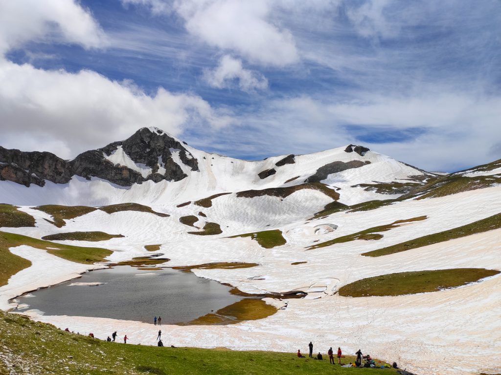
Reaching the Dragon Lakes requires hours of hiking, but that’s part of the magic. When you arrive, the effort pays off. Silence all around, no trees or bushes in sight, just an open alpine landscape. The light at that altitude gives everything a different feel. The rocks look brighter, the air feels clearer, and the water reflects the sky like a mirror. Standing there, with nothing but silence and wide-open views around you, the lakes seem almost unreal, like they belong to another world.

When to visit and general information

The best time to go is from late spring to early autumn (June–September), when the snow has melted and the trails are open. During the hike you cross alpine meadows, see rare creatures like the alpine newt, walk among colorful mountain wildflowers, and enjoy sweeping views over valleys such as Vikos Gorge and Valia Calda.


Important: All lakes are inaccessible in winter and require
experienced mountaineering skills during snow season.

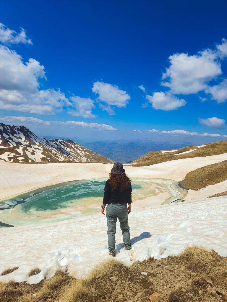
1. Drakolimni Tymfi: The Crown Jewel

Location: Mount Gamila (2,497m) | Altitude: 2,050m |
Difficulty: ★★★★☆

The most famous of the Dragon Lakes offers dramatic views over the legendary Vikos Gorge. This one-hectare lake, five meters deep, sits dramatically on a cliff edge.

How to get there

To reach the Dragon Lake of Tymfi, you first travel to the city of Ioannina, the main gateway to the Zagori region. Ioannina is well connected to Athens with daily flights (about 1 hour), and during summer there are also some seasonal flights from Europe. You can also reach Ioannina by car or bus from Athens (around 5–6 hours) or Thessaloniki (about 3–4 hours).

From Ioannina, the next stop is the village of Mikro Papingo, located about 60 km to the north (roughly 1 hour and 15 minutes by car). You can get there by rental car, taxi, or occasionally by bus. The road is winding but very scenic, leading you into the heart of Zagori.

Once in Mikro Papingo, just before entering the village, there is a parking area. From there, follow the cobblestone path northwest until you reach the trailhead, clearly marked with signs. This is the starting point of the hike that will eventually take you up to the alpine Dragon Lake of Tymfi. If you want more route and planning details, here’s a step-by-step hiking guide to Timfi’s Drakolimni.

The trail

Starting from Mikro Papigko, the trail first takes you through dense forests in Tymfi. As you climb higher, the trees slowly disappear and the landscape opens up to the wide, rocky alpine terrain. The path is easy to follow, with red marks painted on rocks and trees, and signs along the way. You’ll find a few small wooden shelters where you can take a break and refill your water bottles.

The Astraka Refuge sits on a ridge at 1,950 meters, close to Astraka Peak. From Mikro Papigko, it’s about 5.5 kilometers and takes roughly three hours to reach, with a climb of around 910 meters. The refuge provides beds and hot meals, and the views from there are breathtaking. Surrounding peaks, alpine meadows, and the seasonal lake Xeroloutsa can all be seen. Many hikers choose to stay overnight at the refuge before or after visiting Drakolimni. In that case booking ahead is recommended.

From the refuge, Drakolimni is about 2.5 kilometers away, taking roughly one hour to reach. The path first goes down about 140 meters into a valley, then climbs again roughly 240 meters to the lake. This final stretch is the most scenic, passing through alpine meadows and spots where horses and wild goats may appear. Drakolimni itself is about one hectare in size and around five meters deep. It formed after the glaciers retreated, and its water stays cold year-round, coming from rain and melting snow. The lake is perched on a cliff with dramatic views of the Aoos Gorge to the northeast. Nearby, Gamila Peak rises to 2,497 meters (the highest in Tymfi) and Ploskos Peak is to the north. Because the area is a fragile alpine ecosystem, visitors should respect nature, avoid disturbing wildlife, and never leave trash behind.

Difficulty Level and Distance

Starting from Mikro Papingo, the hike to the lake is a full-day adventure. It takes around 7–8 hours round trip (17 km) with significant ascents and rocky sections along the way. The route is considered difficult but it isn’t only for experts. Anyone in good shape can take it on. You just need to be careful, move at your own pace, and bring the right gear, since the terrain can be tricky in places.

Where to stay

The villages of Mikro Papigo and Aristi are excellent bases for exploring Tymfi, offering cozy guesthouses, small hotels, and mountain-view accommodations. If you seek for a higher-altitude experience, the Astraka Refuge provides direct access to alpine trails.

The Hike:
  • Start: Mikro Papingo village
  • Distance: 17km round trip
  • Time: 7-8 hours total
  • Highlights: Astraka Refuge (overnight option), alpine meadows, wild goats
Trail Breakdown:

Mikro Papingo to Astraka Refuge: 5.5km, 3 hours (910m elevation gain)
Astraka Refuge to Drakolimni: 2.5km, 1 hour (net 100m elevation gain)

2. Drakolimni Smolikas: The Heart-Shaped Wonder

Location: Mount Smolikas (2,637m) | Altitude: 2,150m | Difficulty: ★★★☆☆

Beneath Greece’s second-highest peak lies this unique heart-shaped lake with deep blue waters that turn reddish at the edges.

How to get there

The journey to the Dragon Lake of Smolikas begins at the Smolikas refuge near the village of Palioseli. Refuge is located at 1,700 meters on a lush forested slope and is accessible by a 7 km dirt road from the village. From there, a marked trail leads hikers to the alpine Dragon Lake, 5 km away at 2,150 meters. Continuing along the path for another 2 km and about 1.5 hours of hiking brings you to the summit of Smolikas. Because public transport only reaches nearby villages, the easiest way to explore the area is with a rental or private car.

The trail

The hike to Smolikas’ Dragon Lake begins from villages such as Agia Paraskevi (Kerasovo), Paleoselli, Pades, or Pournia. The most common route starts from Pades and involves forest paths, dirt tracks, and marked mountain trails. The trail takes you through dense pine and pine forests at lower altitudes and opens up into alpine meadows and rocky terrain as you climb. The hike usually takes around 4 hours from the starting points. Water is available along the way, but it’s recommended to carry enough for the entire hike. The lake is located at an altitude of approximately 2,150 meters and covers 4,000–6,000 m² in an irregular, heart-like shape. The water is deep blue, turning reddish near the edges. A small stream flows from the lake down the cliff, adding to the dramatic scenery. Surrounding alpine meadows bloom with wild orchids, lilies, and violas in spring. In winter, the lake freezes over and the whole area is hard to reach. But when spring comes and the snow melts, you can see alpine newts in the clear waters, while the surroundings turn calm and almost magical.
Where to stay
Konitsa is a convenient town for reaching Mount Smolikas, while smaller villages like Pades offer local guesthouses.
Highlights
  • Irregular heart shape covering 4,000-6,000m²
  • Small stream cascading down cliffs
  • Spring blooms of wild orchids, lilies, and violas
  • Alpine newts visible in clear waters
The Hike

Start: Paleoselli village via Smolikas Refuge
Distance: 17km round trip
Time: 6-7 hours total
Highlights: Dense pine forests, alpine orchids, possible summit extension

Difficulty Level and Distance
The classic route begins at Paleoselli and climbs about 6 km (3 hours) to the Smolikas refuge, gaining 700 m in elevation. From the refuge, it’s another 7 km (3–3.5 hours) to reach the lake at 2,150 m. The total distance for the round trip is roughly 17 km, taking most of the day. There is also a shorter approach starting from Pades village, which merges with the refuge trail. The hike is moderate to difficult, mainly due to the length and elevation gain.
Verlinga lakes mountain landscape Greece

3. Drakolimni Gistova: The Remote Giant

Location: Mount Grammos | Altitude: 2,350m | Difficulty: ★★★☆☆

Greece’s highest and largest alpine lake sits near the Albanian border in one of the most remote locations in the Pindus range.

How to get there

The starting point for reaching Lake Gistova is the small mountain village of Grammos (also known as Grammousta), one of the most remote settlements in the Pindus range, close to the Greek–Albanian border. The nearest main city is again Ioannina. From Ioannina, the road continues northwest through Konitsa and into the Grammos area. Because public buses only reach larger towns, the most practical way to get to Grammousta is by rental or private car. Once in Grammousta, the trail to Lake Gistova begins just outside the village. Following old herdsmen’s paths, you pass through the alpine meadows of Lefka and continue toward the areas known as Barouga and Fagou. The hike crosses open, treeless landscapes at high altitude until you finally reach the natural basin of Gistova, the highest and largest alpine lake in Greece at 2,350 m.

The trail

The journey to Gistova, the largest alpine lake in Greece, starts in the small village of Grammos, near the border with Albania. From the very beginning, the trail shows the mountain’s rugged beauty: rocks, steep paths, and wide open skies. The climb is steady, taking you higher into the Grammos Mountains, where snow stays late into spring. As the snow melts, small green plants and alpine flowers begin to appear along the path. The trail winds through rocks and narrow ridges, and the quiet of the mountains surrounds you. The climb is not easy, but the views keep you going. From higher up, you can see peaks stretching far into the distance, making the effort feel worthwhile. Finally, the trail leads to Gistova itself, sitting at 2,350 meters. The lake is not very deep and its bottom is covered with grey stones. In spring, some green plants grow around it, softening the rocky surroundings. In winter, the lake freezes and is covered with snow, so it cannot be visited.

Difficulty Level and Distance

Starting from the picturesque mountain village of Grammousta, the path begins with a moderate incline through dense woodland before transitioning to more exposed alpine terrain as elevation increases. This hiking trail offers multiple route configurations to suit different experience levels and time commitments. The shortest option covers approximately 7 kilometers one-way, requiring about 3 hours of steady hiking to reach the pristine alpine lake. This route is classified as easy to moderate difficulty, making it accessible to most hikers with basic fitness levels. If you seek for a more comprehensive experience, the longer lake route spans roughly 12 kilometers and takes 5-6 hours to complete. This variation typically includes additional viewpoints, alternative return paths, or exploration of the surrounding alpine meadows and secondary peaks in the area. The most ambitious option combines the lake visit with an ascent of Mount Grammos, towering at 2,520 meters above sea level. This demanding route requires over 6 hours of hiking and is rated moderate to difficult. The summit push involves steeper terrain, potential scrambling sections, and requires good physical conditioning and mountain hiking experience

Where to stay

Gkistova Lake lies in a remote alpine area, with the closest overnight stays in Kefalovryso or Grammousta.

The Hike:

Start: Grammousta village (very remote)
Distance: 12-14km round trip
Time: 5-6 hours
Highlights: Complete wilderness, cross-border mountain views

Most isolated of all Dragon Lakes

Verlinga lake in Greece

4. Drakolimnes Flegga: The Twin Beauties

Location: Mavrovouni Mountain | Altitude: 1,960m & 1,940m | Difficulty: ★★☆☆☆

Two connected lakes (Laklou Mare and Laklou Nikou) offer the most accessible Dragon Lake experience within Valia Calda National Park.

How to get there

The starting points for reaching the Flenga Dragon Lakes are the mountain villages of Vovousa and Metsovo, both located in the Pindus range. From there, after a short drive, you can access the trailheads leading up to the lakes. There are three main hiking routes: the first begins at Arkoudorema, near its junction with the “Mnimata” stream, the second follows the “Salatoura” stream and the third starts at the Salatoura Milias pass, climbing along the ridge of Mavrovouni. Each route takes about 3–4 hours of hiking through alpine meadows and rugged mountain terrain before reaching the twin lakes of Flenga. If you are driving a 4×4, there is also an alternative route from Lake Aoos: after 5 km of dirt road, you can reach the ridge, from where the summit of Flenga becomes visible, with the two lakes lying just below it. The trailheads can be accessed by car from Metsovo or Vovousa. Both are connected to Ioannina by road. Public transport is very limited, so the best option is to rent a car. Be mindful of shepherd dogs in the area, as flocks graze freely on the mountain slopes.

Difficulty Level and Distance

From the Mavrovouni refuge, the twin lakes can be reached with an 11 km round trip (about 5–6 hours). Longer versions of the route (15 km, up to 10 hours) are sometimes included in guided excursions that also visit Arkoudorema. Trails are easy to moderate, requiring good stamina but no technical climbing.

Where to stay

Near the Flegga Lakes, mountain refuges such as Mavrovouni and Valia Calda are the closest options, though nearby villages like Metsovo also provide lodging and easy early access to the trails.

Family-Friendly Option

This family-friendly option offers the gentlest terrain of all the Dragon Lakes, making it the ideal choice if you are a family with children or a hiker seeking a more relaxed experience. The relatively easy walking conditions mean that even younger children and less experienced hikers can enjoy the journey safely and comfortably. A scenic stream connects the two lakes, creating a picturesque waterway that enhances the natural beauty of the area. The location provides excellent views of the expansive Valia Calda valley, offering you spectacular panoramic views. During spring months, the area comes alive with vibrant wildflower displays that add bursts of color to the already stunning landscape.

The trail

From the start, the trail winds gently upward, flanked by small streams, scattered rocks, and low mountain vegetation. After a short while, the path enters a sparse forest of firs and pines, where the trail steepens and rocky stretches demand careful footing. After roughly an hour to an hour and a half, the forest gives way to the subalpine zone, around 1,800 to 1,900 meters. Here the landscape opens dramatically, revealing distant ridges and peaks, with the rocky ground dotted with grass, low shrubs, and vibrant wildflowers. The final ascent continues uphill for another half hour to an hour, where the first lake, Laklou Mare, comes into view. Its waters are a striking deep blue, tinged with red near the banks, and it feeds a smaller neighbouring lake, Laklou Nikou, which lies just below. A small stream carries the water from the higher lake down toward the Arkoudorema valley, creating a serene, continuous flow. At the lakes, the scenery is breath-taking. The two twin-like bodies of water rest side by side, surrounded by lush slopes in spring, with colourful flowers and patches of alpine grass. Occasionally, alpine newts can be seen in the clear waters, and the view stretches across the entire Valia Calda valley, framed by distant mountains.

The Hike:

Start: Multiple options from Metsovo/Vovousa area Distance: 11km round trip Time: 5-6 hours Highlights: Twin lakes, easiest access, spectacular valley views

5. Drakolimni Verliga: The Circular Legend

Location: Mount Lakmos | Altitude: 2,050m | Difficulty: ★★★☆☆

Named for its circular shape, this lake comes with the most colorful local legends, including tales of dragons creating major rivers.

How to get there

The starting point for reaching Lake Verliga is the mountain village of Chaliki (or Haliki), one of the highest villages in Greece (1,150 m on Mount Lakmos). From Athens, the drive takes roughly 6 hours. You can get there also from Ioannina with a 1 hour and 40 minutes drive. Chaliki is the main gateway to the hiking trails that lead up to the alpine plateau of Verliga. From the village, it’s about a 5-mile (8 km) hike through beautiful alpine meadows and streams until you reach the circular lake at 2,050 m, surrounded by the peaks of Tsoukarela and Megas Trapos. Public transport does not reach Chaliki, so the best option is to rent a car. The village can also be accessed from Ioannina via Metsovo and Katara Pass, making it possible to combine Verliga with visits to other Pindus highlights.

The trail

The journey to Verliga Lake begins in the village of Chaliki, near the springs of the Aspropotamos River. From the start, the path shows the mountain’s beauty, with green meadows, streams, and small waterfalls. In spring, yellow and purple flowers cover the slopes, making the whole area feel alive. The trail is partly a forest road and partly a hike through fir trees, leading steadily up to the lake at 2,050 meters on Mount Lakmos. Along the way, you may see shepherds with their flocks. Verliga Lake is not perfectly round, but its swirling waters give it a circular feel, which is how it got its name. The lake is located among the alpine landscape, with rocks and green plants surrounding it. The hike can be tiring, but every step brings beautiful views of streams, waterfalls, and mountain scenery. There is a local legend that a dragon shaped like a snake burst out from the rocks here, creating the waters that form the Aspropotamos and Acheloos rivers. Shepherds also call the lake Farmakolaka, or the “poisoned basin,” because the legend says animals that grazed there sometimes died.

The Hike

Start: Chaliki village (1,150m)
Distance:
16km round trip
Time: 6-7 hours
Highlights: Aspropotamos River springs, mountain waterfalls

Difficulty Level and Distance

From the village of Chaliki, the path to Verliga is about 8 km one way. The hike usually takes 3–3.5 hours each way. The trail itself is not technically hard, but the sustained climb makes it moderately difficult.

Where to stay

For Lake Verliga, the best starting points are villages in the Pindus Mountains, such as Peristeri and Haliki, while Metsovo or Ioannina serve as comfortable but slightly farther bases.

Equipment Needed

The trails to the Dragon Lakes can be long, steep, and sometimes unpredictable. To enjoy the hike safely, it’s important to bring the right gear.

Water: At least 2L per person. If you plan to refill on the way, a small water filter is very useful.
Snacks & Food: Nuts, fruit, or energy bars will keep you going during the climb.
First Aid & Personal Items: A small kit with bandages, medicine you may need, and basics like tissues or sanitizer.
Boots: Strong hiking boots that cover your ankles are a must for rocky paths.
Layers: Wear clothes that dry fast and pack something warm – mountain weather changes quickly.

Rain Protection: A waterproof jacket and pants for sudden storms.
Sun Gear: Hat, sunglasses, and sunscreen.
Backpack: Around 25–30L is enough for food, water, and clothing.
Trekking Poles: They help a lot with balance and reduce pressure on your knees.
Rain Cover: For your backpack so your things stay dry.
Camping Gear (optional): Bring a tent and sleeping bag only if you want to stay overnight.

FAQ

1. Can beginners attempt the Dragon Lakes hikes?
While Flegga Twin Lakes offer the most beginner-friendly option, all Dragon Lakes require good physical fitness (6+ hours hiking ability), proper mountain gear, and experience with challenging terrain. The combination of high altitude, rocky paths, and rapidly changing weather makes these hikes unsuitable for casual walkers. We recommend building experience on easier mountain trails first and considering a local guide for your first Dragon Lakes adventure.
2. What’s the weather like at the Dragon Lakes?
Summer temperatures range from 15-25°C (59-77°F) during the day but can drop to 5-10°C (41-50°F) at night, with temperature falling roughly 6°C per 1000m elevation gain. Weather changes rapidly in the mountains – a sunny morning can become a stormy afternoon with possible snow even in summer. Always pack warm and waterproof layers regardless of the forecast, and be prepared for strong UV exposure at high altitude.
3. Are there any dangerous animals or plants to worry about?
Wildlife is generally harmless, but be cautious of protective shepherd dogs (maintain distance), rare wild boar (make noise while hiking), and vipers (stay on trails, wear proper boots). There are no significantly dangerous plants, though avoid eating unknown berries or mushrooms. The real dangers are environmental: loose rocks, sudden weather changes, getting lost, and altitude effects – these pose far greater risks than wildlife.
4. Do I need a guide or can I hike the Dragon Lakes independently?
Most experienced hikers can navigate the Dragon Lakes independently using marked trails and GPS devices. Local guides cost €100-150/day and provide invaluable knowledge about weather patterns, route conditions, local legends, and emergency procedures. Solo hikers should inform someone of their route, carry offline maps, emergency equipment, and have mountain rescue contact numbers. First-time visitors or those unfamiliar with alpine environments should strongly consider guided tours for safety.
5. Which Dragon Lake should I visit if I only have time for one?
Drakolimni Tymfi offers the most rewarding single-lake experience with dramatic Vikos Gorge views, the comfortable Astraka Refuge option, and the most developed trail infrastructure. However, if you prefer easier access, choose Flegga Twin Lakes for moderate difficulty and beautiful dual lakes, or Smolikas for the unique heart-shaped lake beneath Greece’s second-highest peak. Avoid Gistova for single-day trips due to its remote location requiring significant travel time.
6. Can I visit multiple Dragon Lakes in one trip, and what’s the best order?
Yes, visiting 2-3 lakes in a 4-7 day trip is possible with careful planning and a rental car. The most logical routes are: Northern Circuit (Smolikas → Gistova → Flegga) or Southern Circuit (Tymfi → Verliga). Allow full rest days between challenging hikes, stay in different base towns, and avoid attempting more than one lake per day. The complete 5-lake circuit requires 8-10 days and excellent physical conditioning – most visitors find 2-3 lakes more enjoyable and manageable.
About Globevoyaging
Alexandra and Thanos are two software developers from Greece who turned their passion for travel into a travel blog. They like to travel like snails — slow and happy! They love slow travel and experience life like the locals do. Road trips and hiking in nature are a great passion for both of them. They take big walks in forests, climb mountains (well, little ones too!), and drive around in their cozy car to find secret lakes or sleepy towns. They love eating snacks by campfires and laughing when their shoes get muddy. And guess what? They don’t need fancy stuff to have fun! They save their coins for local delicacies and gas to keep exploring.
en_USEnglish
Skip to content